 |
NIGEL ROBERTS Walking through history on the Offa’s Dyke Path |
|
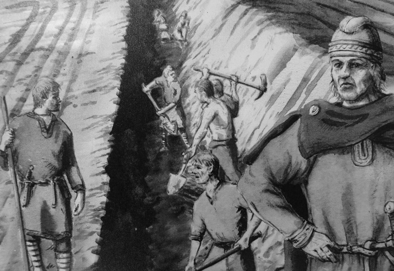
Well over a thousand years before Donald Trump energised his first presidential campaign with the words “Build the Wall”, a man in what we now call England had a similar idea. To prevent incursions by his enemies in Wales, Offa – an Anglo-Saxon king who ruled Mercia from 757 to 796 AD – ordered large defensive earthworks to be built.
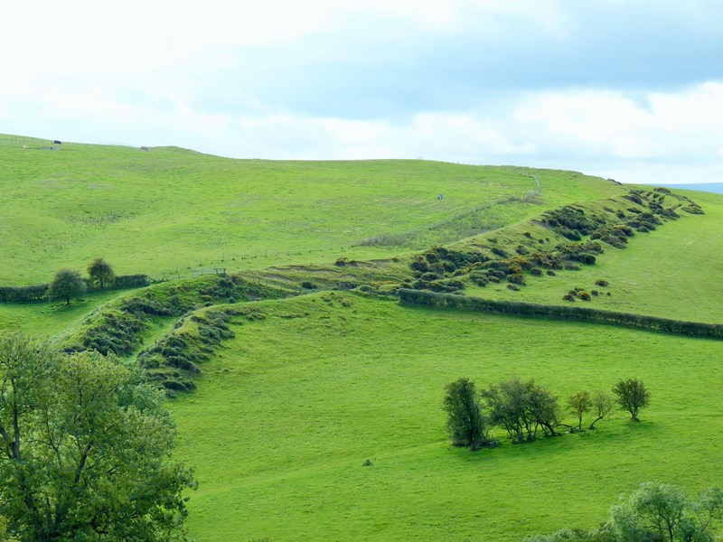
The fortifications, which stretched from the River Dee in the north to the River Wye in the south, became known as Offa’s Dyke. They were so large that more than 1,200 years later, significant portions of Offa’s barricades are still clearly visible in western England and eastern Wales – and a great way to see them is to walk the Offa’s Dyke Path.
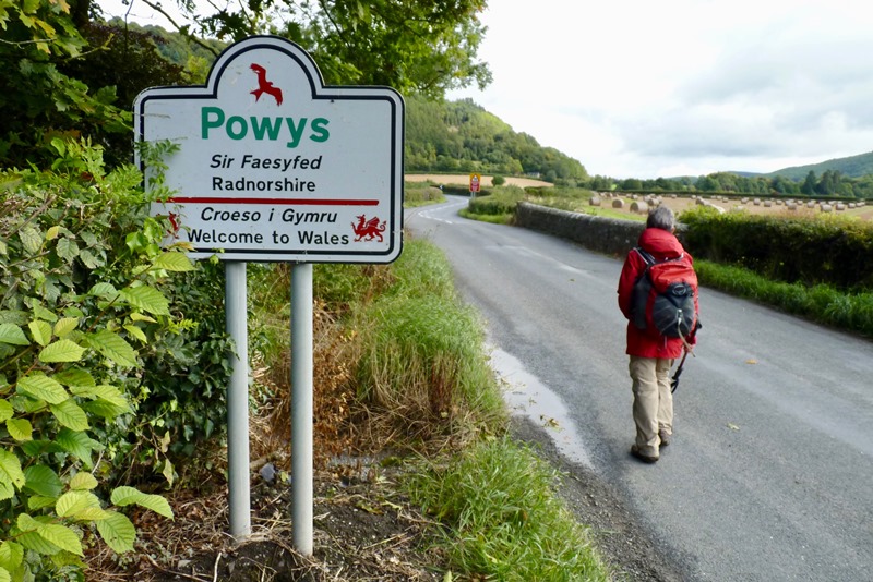
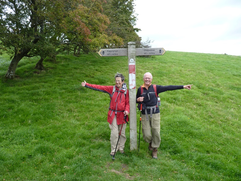
The path is one of 16 National Trails in England and Wales, which have been described as “long distance walks through some of the very best landscapes the UK has to offer.” They are the equivalent of New Zealand’s Great Walks. Ten years ago, my wife, Heather, and I, and friends from California, Bob and Peggy, decided to do the walk. The idea had been planted in our minds by a South African doctor we’d met when the four of us were walking the Camino de Santiago in Spain. We chose a small Lancashire company to make the arrangements for us: it devised our 15-day itinerary, it made our bed-and-breakfast bookings, and it arranged for our suitcases to be transported on a daily basis from lodging to lodging. We are very pleased we paid to have the logistical work done for us: on the third day of our walk, we met an English couple who had planned the walk themselves and booked their own accommodation – tasks, they told us, that had taken them nearly six months. All we had to do was carry small day-packs, buy our own lunches and dinners, and – crucially – hike an average of 19 kilometres a day. The four of us opted to walk from south to north. We left Chepstow (which is near the Bristol Channel) on September 16, 2015, and we arrived in Prestatyn (which is in north Wales, on the Irish Sea coast) on September 30. A tile marking the start of the trail in Chepstow told us that “the path passes through eight counties and crosses the English and Welsh border over 20 times.” On our first morning, for example, we left Monmouthshire (a Welsh county) and crossed the River Wye into Gloucester (an English county). On other occasions, however, the border between England and Wales wasn’t at all obvious, and we only knew we were crossing a border because a road sign told us so. On one occasion, we looked at our map while we were walking down a narrow country lane and realised that we were, in fact, walking along the border.
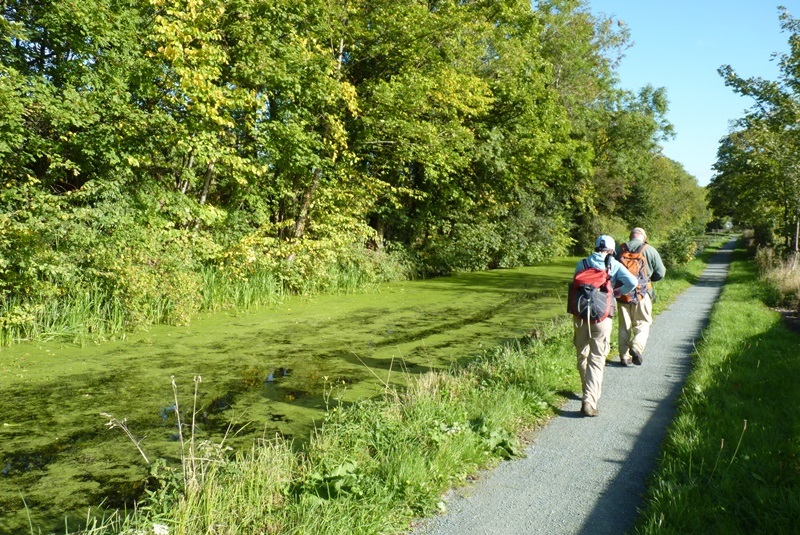
Sometimes the walking was easy: along riverbanks or beside canals.
More often, however, the Offa’s Dyke Path took us up and down hills. The Black Mountains in southern Wales and the Clwydian Range in northern Wales are not high by New Zealand standards. The summits we climbed were only about 550 metres above sea-level (in other words, not much higher than Hawkins Hill in Wellington or the Sugarloaf on Christchurch’s Port Hills), but hiking them undoubtedly requires above-average levels of fitness. It also rewards you with stunning views across landscapes that have few parallels in New Zealand.
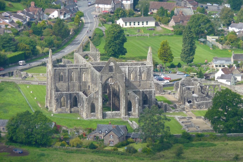
Walking along the Offa’s Dyke Path is a wonderful way to see and absorb aspects of British history. Only a few hours after we left Chepstow, while we were heading north on hills above the true left bank of the Wye River, we looked down onto the ruins of Tintern Abbey, a large church built by Cistercian monks in the 12th Century but destroyed in 1536 on the orders of Henry VIII during the dissolution of the monasteries.
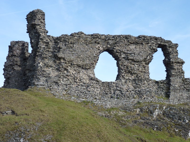
The next day we delved further back in time when we explored Monmouth, birthplace of Henry V. In the centre of the town, there’s a statue of him – carrying a golden mace and wearing a gold crown – high above Agincourt Square, which is named after the site of Henry V’s famous 1415 victory over French forces. Far older than the two Kings Henry, though, were the Iron Age hillfort, Caer Digoll that we encountered on the ninth day of our walk, and the site of a bronze-age burial mound atop a peak in the northern Clwydian Range, that we saw on the second-last day of our hike. They were somewhere around 2,000 and 3,500 years old respectively. King Offa wasn’t the only person worried about the Welsh. Successive English kings constructed castles on or near their borders in attempts to subdue their Welsh foes. As a result, we came across numerous castles during our 15-day walk up the eastern extremities of Wales. Our Cook’s tour of castles began in Chepstow when we stayed in the Castle View Hotel. The name was certainly not misleading: from its windows we could see the castle just a few hundred metres away. It had been built in 1067 by a close friend of William the Conqueror. A few days later we walked past White Castle, another of the Norman castles in Wales, where I was intrigued to find a small footnote to much more recent history. Rudolf Hess, the deputy-leader of Adolf Hitler’s Nazi Party, was captured in 1941 while he was on a secret mission to Scotland. For the rest of the Second World War, Hess was held as a prisoner of war near Abergavenny, a small Welsh town, but on occasion – watched-over by two squaddies – he was allowed to walk, paint, and sketch in the White Castle area. The last castle we visited was on Day 13 of our hike. Castell Dinas Bran sits high on the hills above Llangollen (a town that’s home to a well-known international music eisteddfod). Dinas Bran was the least well preserved of all the castles we saw, but it was possibly the most memorable, because it has been accurately and alliteratively labelled as “atmospherically Arthurian in aspect.”
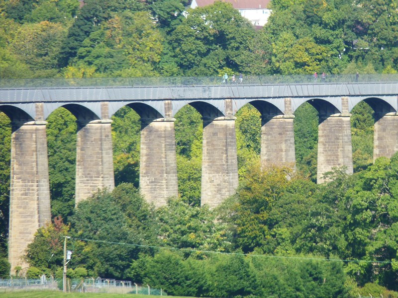
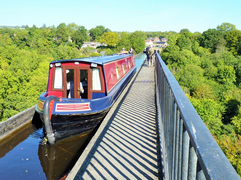
However, the most amazing construction we saw was neither a castle nor a church. It was the Pontcysyllte aqueduct, which carries the Llangollen canal across the River Dee. Designed by Thomas Telford and William Jessop, and built between 1795 and 1808, it’s the highest navigable aqueduct ever erected. It’s a whopping 37 metres above the river. As one Offa’s Dyke guide book says, the aqueduct is “one of the highlights of the entire walk – though it’s not for anyone who suffers from vertigo.” The Pontcysyllte aqueduct and canal are deservedly a UNESCO World Heritage site.
When we reached the Irish Sea after 15 days of walking, Bob made his way to the water’s edge and ceremoniously threw a small stone into the sea. He had picked it up near the Bristol Channel before we left Chepstow. Our walk was over, but it’s one we’ll never forget. The scenery is outstanding. It’s Britain at its best. The weather had been unusually good. We’d had brief bouts of rain on only three days, which included just one heavy downpour. The path is very well sign-posted: we went astray – and were somewhat lost – only twice during our 285-kilometre trek. None of the accommodations we stayed in was sub-par. Indeed, three of our bed-and-breakfasts were exceptionally good. The vast bulk of the route is off-road; a very small proportion is on roads (and they are usually minor ones). Just outside Chepstow, at the start of the walk, there’s a sign that says, “Good Luck! You’ve just completed the first few steps of Offa’s Dyke Path National Trail. Only 284 km (177 miles) to go of an epic journey along the story-rich border of England and Wales.” Fifteen days after I saw that sign, I could only say, “Hear! Hear!” The inscription on it is wholly accurate. Walking the Offa’s Dyke Path is, without doubt, a trek through the story-rich history of Britain. * * * * * * * * * * * * * * * * * * * * * * * * * * * * * * Nigel Roberts is an emeritus professor of political science at Te Herenga Waka / the Victoria University of Wellington. Detailed illustrated accounts of his travels can be found on his website (www.nigel-roberts.info). * * * * * This article was published in The Post, Wellington's daily paper, as well as in other newspapers in the Stuff stable, on Monday, March 10, 2025. (The headline The Post gave the article was "Walking Through History".) * * * * * |
||